

day 12/13 – 14/15.07.09 – Kobenhavn/Copenhagen
Posted: August 16th, 2009 | Author: Gergana Milusheva | Filed under: fun, trips and notes | No Comments »The post about Copenhagen is perhaps the toughest one for me in this story.
was it the fact that the city enchanted me right away last year but did not miss the chance to show me that this had been no accident when I came back this year?;
was it because of all the idols of my growing-up architectural brain happily cohabit here or because of the way Danish women live among them…
or was it just because of the bikes;
it is easier to write poetry about the Norwegian fjords than to answer the question: Why is Copenhagen so amazing?; there is no way I can express my attitude towards that place using pathetic words or showing pictures; perhaps due to my professional curiosity or my search for the answer of the question, I decide that only architectural facts can solve the issue; maybe a careful look at them can reveal the secret recipe of this enchanting city;
a quick look at their own attitude on the topics of design and architecture:
it is indicative of their views 🙂 – one is never too young to enjoy a good design…
an overview

it is easy to see where the old town used to be
the beginning – the 11th century; a capital – the early 15th century
a literal translation of its name – a traders’ harbor
population as of 2009 – 1.16 million people, 1.87 including the vicinities (34% of all Danish people)
summer temperature 20 / 25C; winter temperature -2 / -4C.
gross domestic product per capita is 62,000 USD (in comparison: USA – 47,000, France – 40,000, Germany – 44,500, Russia – 11,800, Romania – 9,300, Bulgaria – 6,800)
Denmark is the second most peaceful country after Iceland
in 2008, Copenhagen won the 4th place in the top 50 “European Cities of the Future” following London, Paris and Berlin
the Most Liveable City in the World (there is no way I am translating this!)
the most environmentally-friendly city and the cleanest one; its inner port is so clean, you can swim there
the happiest place
with the lowest level of corruption….
the city is situated on two islands between the straits that divide the Atlantic Ocean from the Baltic Sea; post-war Copenhagen was planned by a radial vector field principle, or the so-called five-finger system; its rapid development, growth and transformation of the city’s structure began after the opening of the bridge/tunnel leading to the Swedish Malmö (Oresund Bridge) – the distance is just 30 kilometers; Sweden is also a member of the EU but salaries are higher in Denmark…. there were all sorts of industrial facilities along the main canal that divides the two islands that took advantage of having a direct sea outlet; up until recently…
here is another video on their attitude towards their city
(1) is the oldest one; (2) is Friedriksberg
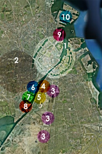
this neighborhood is definitely not amongst the new ones; and it definitely isn’t a neighborhood, actually, but a city within the city; it is considered the most prestigious place to live in Copenhagen and only in 2007 did it lose the status of an independent region in the country (a region!, not a municipality…); but it still is the most densely populated district – 100,000 people on 8.7 km²; due to the densely build-up area, the intervention of contemporary architecture is cautious and precise: it appears only at a few places.
Friedriksberg – the subway
The transformations of the city here are battling for yet another piece of the city free of roads: the subway and the roads are taken underground in order for the space above to be reclaimed accordingly. The space is big enough, so this process includes the construction of new buildings: a cinema, a library, a fitness center and hundreds of housing units for young people with shops at the ground floor level. The expression for that used by the Danish is “promoting city life”. Like they need to do that!


(the pictures are not mine)
F.L. Smidth
the authors of this urban plan are the prominent and outstanding locals: Henning Larsen Architects; the Copenhagen Opera House
the local Danish architects have to participate in competitions… and, apparently, they have the skill to win them. 2004. urban planning does not fit the widely accepted definition, it is more of an “open code” (ring any bells…?), where there are a few basic rules set, based on preserving the transformation of the industrial buildings and adding new apartment and office buildings around them as well as recreation zones (wow, the bad connotation these words have come to have… but we don’t have others).
The construction works are just beginning and they are supposed to continue for 7 to 9 years; new/already existing:


Nimbusparken
this new neighborhood (a former industrial zone that existed during the first half of the 20th century) is the result of a competition, won simultaneously by two architectural studios:
– one from Berlin, offering themed city parks
– an urban solution with local buildings
the final planning that incorporated the two winning solutions was developed by a third team; a portion of the industrial architecture was preserved and transformed into apartment buildings with a lot of windows, 3.5 meters high; (I don’t think anyone was upset about that)
30% apartments
70% offices
construction is still underway

Flintholm
similar to all contemporary Danish urban planning, this town forces the combination between private and public environment; the place is close to the prestigious Fridriksberg with its characteristic green, private yards, open to the street and the open apartment building facades with balconies; the height of the building is between two and six floors and it is open towards the park and sports zone.
the main shopping street
kindergartens and day-care
in-line houses with yards and apartment buildings
and this is only the beginning of construction works

that’s it for number (2)
we move on to the more interesting part
and we begin with the best, the most massive urban planning project in Copenhagen: number (3) on the map above; it is called
Restad or, as they spell it, Orestad (the letter “O” is crossed out but I cannot type that)
the place is the former common city pasture; yes, you read that correctly – a common pasture; I double checked the meaning of it with the dictionary… in other words: it is urban planning at its purest, in the middle of nothing… almost like in Brazil but in the 21st century.
1994
the city of Copenhagen (not exactly, but anyway, the initiator was a country + a municipality) organized an urban planning competition; the brief said the following:
“The new district must function as a counterpart to the old city centre of Copenhagen and contain an urban environment of exquisite artistic and environmental qualities that may function as a laboratory for new ideas.”
total area of the district – 3,100,000 sq. m
1995
the competition is won by the Finnish company ARKKI, as it says, a young architecture firm; it is so young that despite my efforts I couldn’t find anything about them online; apparently this is not an obstacle 🙂 ; their competition-winning work is based on four primary principles applicable to the organization of Orestad
– a relationship between construction and nature sites
– a solid infrastructure for pedestrians and bikers
– canals and lakes (do you remember the water from Stockholm….)
– a subway line lifted on columns above the basic street level.
that’s it.
in fact, these 3.1 million sq. m are exactly 600 m wide
more than a third of them are set aside for landscaping and open spaces (and by the way, the sport facilities and playgrounds are NOT included in this calculation)
contrary to what we understand by the term “urban planning”, there is no trace of picturesqueness, lining or anything of that sort
the forecasted end of construction works: 2068; (70 years? but these are close to three generations’ time…)
Orestad consists of four parts – Nord, Amagar, City and South, which are separated from one another by perceivably large blank spaces in the form of parks with cycle tracks that look authentically natural; the four sub-districts develop separately and almost independently from each other; of course, the first thing that was built before anything else was the subway…. (on the picture below: the dark double gray line with red markups for the stops)

the four Orestad districts have very different construction profiles on purpose:
Orestad Nord hosts an abundance of public functions
The University of Copenhagen

our favorite IT University

several dormitory buildings that consequently became benchmarks


and, of course, the Danish Television and Radio, DR Byen along his new concert hall by Jean Nouvel


when I look at the pictures now, I cannot help but think that all of this aims to take the cars out of the urban environment…. all the space, all this freshness and cleanness only because there are no cars!
I got off topic here
so, the district has a lot of apartment buildings but the predominantly public functionalities have transformed it into a R&D center for culture, media and communications.
construction works continue with things like this one
http://www.mikadohouse.dk/#/forside/
which I saw like this

I continue south to the center of Orestad
Orestad City
the center is a typical one; it has a mall (the largest one in Scandinavia), apartment buildings (that I showed you last year), schools and playgrounds for children, administrative office buildings; the majority of these are already complete
it turns out, however, that uncle Libeskind was the author of the urban plan, so bigger things were about to start happening; the only place you can get an idea of what it is going to be like is това (watch the movie)
still, I can’t miss to show you these:


(I am checking how much greener it is, nothing else… 🙂 )
the farthest part from the center is
Orestad South
it is envisioned as the most densely populated zone with housing units for about 10,000 people and work places for 15 000 more; there are meadows south of it and the airport is on the other side of them;
it is the most massive district as a concept but it is also the one who suffers the most from the impact of the economic crisis since construction works here began in the Fall of 2008.
one of the terrains from the relatively orthogonal matrix planning participated in this year’s Europan
we had video for another one in a previous post
and to my surprise, it was under construction (it seems the economic crisis does not apply to those who are genius)
a quick look around


the building next to number 8 is the only one that is finished in the district;

and inhabited 🙂
the places marked (4), (5) and (6) are Havenstaden and Bryggen Syd – the first ones in the city’s great transformation that have almost no trace of construction works left
former harbor territories with enormous industrial buildings, factories and all kinds of dirty works, they are now the city’s new face with the typical mixed buildings (in this case: housing units and parks right on the waterfront and offices plus shopping areas on the next line); the Opera House and the new library can be seen further on the canal; a portion of silos are also preserved and transformed
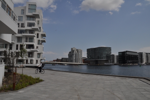
and the great feel of open air spaces again…
I continue to the number (8) circle,
Sluseholmen
the neighborhood is designed based on a Dutch model; it is built on 8 artificial islands which have canals between them and inner yards; the urban plan is a set of rules which guarantee that some common principles will be followed, achieving a varied and exuberant final outlook at the same time; in order to achieve this effect, they invited 25 studios to design the buildings in the neighborhood and, by definition, there were at least 5 studios working on every single block; the height: 4 towards the inside and 7 floors to the main canal
here is the result


the main canal

this is what stands at the cape
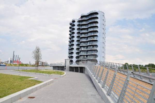

it is an apartment building, in case you were wondering, and it is as controversial as it seems…
the last two parts of the city under development, 9 and 10, are also former harbor areas
9 Amerika Plads
Is significantly different from all other parts of Copenhagen; it is conceived in the American way, with the large, massive compound around central square spaces; the areas has also kept some of its former charm of a free harbor since a portion of the warehouses are preserved and included in the new urban environment (sounds familiar?); here is how I saw it:


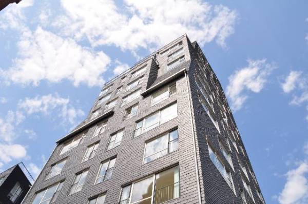


unfortunately, there isn’t any information about number 10 anywhere… just a few modest visualizations of a massive project that must have suffered from the economic crisis…
and if I had finished this post last week, there would have been plenty of morals to the story
luckily, I did not!
I am posting a video for some Danish colleagues instead (guess who they are…);
all that is left to do now is for me to wish everyone a lot of patience and really tough skulls (because slamming your head in the wall is the least you can do), so that one day we get the chance to have such visionary politicians and urban planners (or that we become those people)… good luck!
ps: if anyone really liked Norway and did not get enough of it from the pictures in the posts, here are some more of them with better quality as well.
